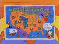
Krusty Burger Fun Map
Wikisimpsons - The Simpsons Wiki
Krusty Burger Fun Map
| ||||||||
Object Information
|
The Krusty Burger Fun Map is a map of North America that is part of Krusty Burger's merchandising, emphasizing areas where Krusty Burger branches are located.
History
After Homer and Bart, along with Ned and Rod, were lost at sea aboard a raft, Homer smelled hamburgers. According to the maps, he guided the raft to a Krusty Burger restaurant that had been built on an offshore oil rig.
Behind the Laughter
Mississippi is incorrectly labeled as MI. Mississippi's official postal abbreviation is MS; Michigan's is MI.

